|
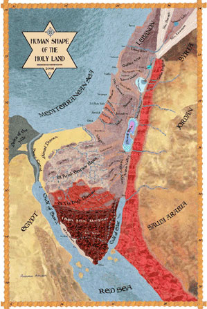
Optical Illusions and the Human Shape of the Holy Land Many viewers of
the Holy Land Map find it difficult to identify the human figure which is
hidden in the landscape. They believe that they look at an ordinary map of
the Land of Israel and do not see the human figure with characters parallel
to that of the landscape. The reason is the numerous Geographical details of
the picture, which force the eyes to focus on them, while loosing the general
view. The eyes tendency to focus on
details on account of the general view is well known and is used by many
artists to create Optical Illusions.
These are images were a second reality is hidden behind what is visible at
first glance. Only after a long observation, and with the help of many clues,
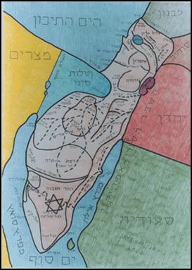
can the viewer of an Optical Illusion discover the hidden image Can
you recognize in the map a
human
figure?
Holy
Land Map as a Human Shape This common use of the eyes
faculties is a trouble for the viewers of the Holy Land Map. The aim of the
map is to clarify at a first glance its objective: The connection between the
landscape of Israel and the human shape. This connection has enough problems
by itself for the imagination. The creator of the map has no needs for
Optical Illusions. The Optical Illusion distracts the mind. It turns the
secondary into primary, in a way that it appears that the whole perception of
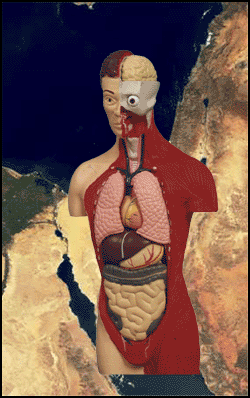
reality is based upon it. The basic idea of the Holy Land Map is combining the Anatomy model with
the landscape of the Land of Israel.
Anatomy
model against Land of Israel To make it easy to discover
immediately the human figure which appears on the landscape, a satellite
photo of the Land of Israel is shown below. A sculpture of a head by the Swiss
artist Giakommeti is placed over the photo's upper part, a neck
from a portrait by the artist Modigliani is placed over the middle, and an
Anatomy model of the torso is placed over the lower part. This combination
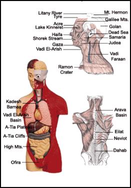
represents the idea of the Holy Land Map as a Human Shape: The face is the
land between the Jordan River and the Mediterranean Sea. The neck is the
Negev Plateau. The torso is Sinai Peninsula. The hair is Jordan Red
Mountains. Angel's rays are the Lebanon Mountains. The
elongated head of Giakommeti's sculpture fits the elongated structure of the
land west of the Jordan River.
Giakommeti's
sculpture on Israel map If
you haven't discovered the human figure yet, please go back to the map on top and try again to find it.
The landscape lines do not
mach exactly the lines of the human shape. A complicated metamorphosis
process is needed to change the topographic map into a human shape. But the
opposite process exists too: Human beings make constant efforts to compare
between their shape and the landscape form. This fact creates a dialog
between man and landscape. It is a sublimation process. The metamorphosis between landscape and man is represented in the
Human Shape of Israel.
Metamorphosis
between landscape and man There
are few characteristics that must be paid attention for while viewing the
Holy Land Map: The
face part of the Holy Land Map is longer and narrower in relation to the
Anatomic reality. The torso part is relatively wider. The
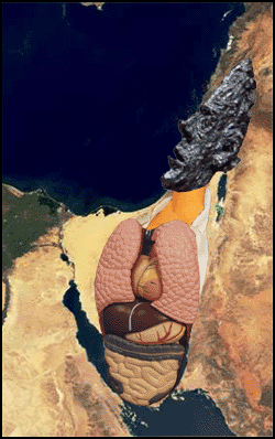
face appears in a profile and the torso more in a front view. The
face of the Holy Land Map appears in its external appearance: You can see the
eye, ear, cheek, nose, mouth, etc. The
torso appears in its interior appearance: You can see the internal organ
systems of the heart-lungs, liver-stomach, and intestines. Illustration to
point out the parallels between the body and the map: Near every body organ
appears the region name to which it is associated.
Parallels
between Anatomy and Israel
The Holy Land Map was created
through a long empirical process. The landscape was examined by satellites
photos and maps, in relation to human portraits and Anatomy models. This is
naturally an infinite process of the imagination, which activate the
important power of the imagination to disintegrate existing formal images,
for recreating them as new dynamic images. You can read about this function
of the imagination in Gaston
Bachelard's books. The creative process is, at first, disintegrating of existing formal
images.
Disintegration
of existing formal images In this way the proper
connection between any land region and any body organ was established. The
next step was a preliminary drawing, where a portrait was sketched according
to the landscape. The illustration emerged as a clear human figure, but the
connection to the landscape became vague. In addition, the character did not
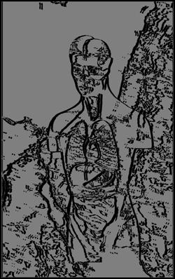
have a sufficient amount of textures and colors. The Holy Land Map was at the beginning, a simple graphic illustration
of a human portrait, without many colors and textures.
Holy
Land Map early version A
renewed modification to the landscape was done afterward and new features were
added. As a result, some of the characteristics of the portrait became less
common. The need to add colors and
textures to enrich the character with details, made it necessary to rely on
the landscape as a source of inspiration. Colors and textures typical to the
paralleling country regions were added. The general approach was to regard
the landscape as the human flesh and skin. The preliminary lines of the
illustration are the skeleton, covered with flesh and skin in the pattern of
the various lands. It was done like one of the basic attributes of human
existence. Resurgence, as a dynamic sublimation process, is an unceasing dialogue
between mankind and earth.
Resurgence This is not the place to
discuss the possibility of a connection between the evolution of mankind and
the landscape of the Holy Land, perhaps via the Birds
Migration. But the use of the landscape for flesh and skin textures is
natural and affluent. When the details seemed to be too many, this usage was
stopped by the Holy Land Map creator. It was for the sake of keeping the
general idea. With the use of powerful Geographical simulators and complex
Anatomy Models, it might be possible to reach much higher levels of details,
even such huge enlargements were anyone will recognize himself personally on
the Holy Land Map
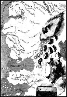
Here is an illustration by
Gustav Dore from 1854, of Russia as an old woman. It comes to illustrate the
combination between Optical Illusions and Anthropomorphic
Maps. The city of St. Petersburg is the eye, The Caspian Sea is the ear, the
chin is above the Black sea, and so on
Russia
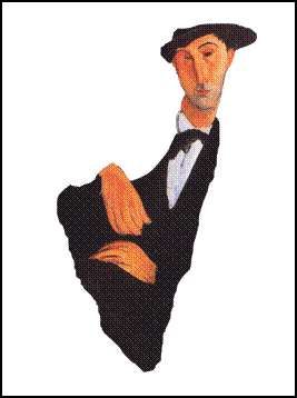
as an old woman The painter Amedeo
Modigliani specialized in characters with an imaginary elongated form. Here is a Modigliani's painting which is integrated very well with the
map of Israel
Modigliani's
painting on Land of Israel End Human Shape of the Holy Land –
Main Page |