Human Shape of the Holy Land
Chapter 4 - The Map as a Work of Art
The concept
'World Image', in Latin 'IMAGO MUNDI', epitomizes the complex nature of
Cartography. It reflects its outlining and artistic sides. Although modern Cartography
uses elaborate measuring tools and removed many of the decorative elements from
maps, maps are still a subject for aesthetic shaping. Moreover, scientific
mapping must show reality selectively because of the use of symbols. Even
accurate maps represent interpretive view point.
It can be
noticed at first sight that art and science existed side by side along the
History of Cartography. Maps connected worlds of religious and folkloristic
symbols with geographic and cosmographic knowledge. The artistic decorations
around maps are a sign of this relationship between art and sciene. These
decorations expressed clear linkage between methods of geographic outlining and
art and style of a certain era. Maps became an influential way of delivering
messages through culture related symbols. Many antique maps represent a visual
extraction of the total knowledge of their creators and they are considered
works of arts.

The natural integration between map and art is
reflected in Ptolemai's world map from the 3rd century
.

An antique European map expresses a Christian
hegemony in the
The
cooperation between cartographers and artists strengthened with the insertion
of picturesque and decorative elements into maps and filling empty areas with
them. Historical and biblical events where added too. A co-existence between
accurate mapping and contemporary art was established.

A map of the
The schematic
and abstract representation of the world is done in maps with a special
alphabet. It contains lines, colors, symbols, shades and more. The design of
maps reflects an artistic tension between shape, content and knowledge.
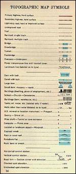
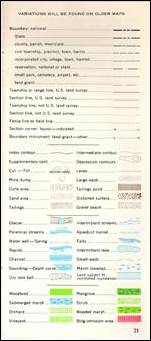
The legend of a modern topographic map contain
dozens of graphic symbols
A senior cartographer
of our time argues: "To capture the essence of the landscape we must
combine the components graphically in a way that an iconic quality will be
received. This aspect of topographic mapping is similar to portrait painting
because its aim is to produce a character which will combine outlining and
expression that reflects the essence of the figure."
Another
senior cartographer says: "A good topographic map must look like a
national monument. It must be a cartographic reflection of the landscape that
represents the relief and other important landscape elements in a way that
emphasizes a geographic uniqueness.
The infinite
accuracy and the sophisticated graphics abilities, together with the
development of visual communications, caused any serious agent who designs a
map in our days to reflect in it convincingly any elements he chooses.
Two maps of
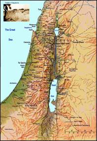
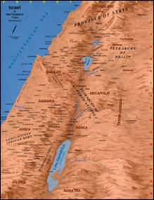
Two topographic maps of
Modern Cartography,
after achieving the complete accuracy of details, may assume that the average
map reader recognizes easily any familiar region. This assumption is used for
creating maps where the terrain is presented in a certain distortion, in order
to illustrate specific facts.
Common
examples are 'bird-view maps' which emphasizes the vertical dimension of the
landscape above its actual scale.

Cram – A bird view of the
Another way
of using the absolute knowledge of the terrain shape is maps where a geographic
unit is resized according to the relative size of a certain data which is the map's
subject. In 'world population maps'
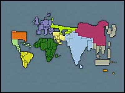
A world population map with relative resizing
of each state
A third popular
style is transforming the map into a simple background for some big images
which are the main subject. In a way it is a 'comeback' to the early maps with
the artistic decoration around the scientific outlining.
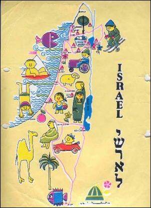
Israel Map for children
Bibliography:
מוזיאון ישראל - ארץ ישראל במפה ממידבא עד הלווין