Human Shape of the Holy Land
Chapter 5 - Early Anthropomorphic Maps
Astronomic
maps are the earliest anthropomorphic maps. Since the dawn of History, man
nicknamed constellations in names from the human environment: Characters,
animals and objects. The Zodiac has a special place. The twelve astrologic
symbols are very popular and their scale of use is an example of the enormous
power of Anthropomorphism in daily life.

The Zodiac Man
The head is Aries, the neck is Taurus, the shoulders are Gemini and so on
The Zodiac
man, where each astrologic symbol is associated with a body organ, is an
example of the varied power of Anthropomorphism. It is possible to determine a
scale of Anthropomorphism by the degree of linkage to the human body.
It is
appropriate to add the mythological character Atlas to the anthropomorphic maps
category, although the globe on his shoulders is not anthropomized directly. Atlas
was one of the Titans, son of Yafetus and the nymph
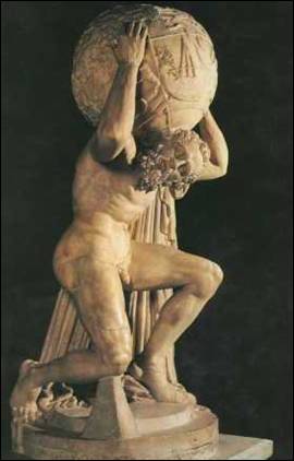
Atlas sculpture – 2nd century
In the middle
Ages the T-O world map was the standard type. In this map the world is a circle
divided by a T shape, with
The T-O map
is an example for the most important anthropomorphic scale: The highest degree
is a description of items as similar to man. Lower levels are of items which
look like animals, objects and concepts.
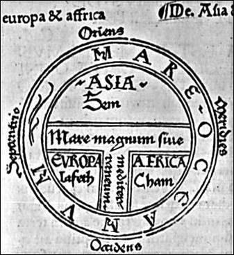
In the T-O maps the world faces eastward and
the T lines represents the major water bodies
The first
clear anthropomorphic map, the Ebstorf Map, was developed from the T-O maps. It
shows Jesus encircling the world with his head, hands and legs.
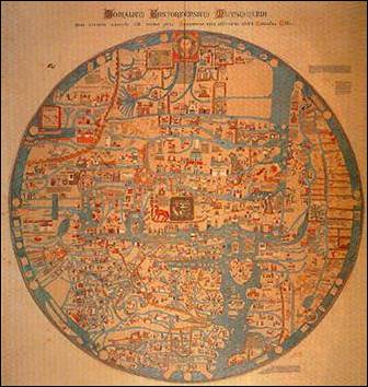
Ebstorf Map – The 13th century
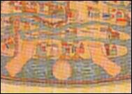
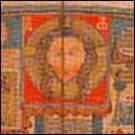
Jesus head, hands and legs in Ebstorf Map
With the
advancement of Geographic research, a more secular genre of anthropomorphic
world maps was developed from the Christian world maps.
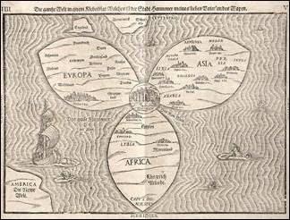
The cartographer Bunting – The world map as a
flower – 16th century

The world map as a clown face – 16th
century

A projection of the world map as a heart